Back to top

100 “metro” networks to serve the whole of France

Research notes
Begin: March 2022
End: April 2022

For us to truly be able to stop using private cars and seriously address the climate crisis, we need to end our current political inaction in an effective and systematic way. Pierre Helwig calls for mobility in France to be radically reinvented by using existing infrastructures to develop collective and active modes, and by proactively pursuing land planning policies aimed at reducing and rationalising travel. He thereby delivers an ambitious, credible and quantified roadmap to achieve France’s carbon goals.

Research participants


With its national low-carbon strategy, France has committed to drastically reducing the carbon footprint of all business sectors, in particular transport which alone represents 30% of greenhouse gas emissions 1. To meet the population’s mobility needs and ensure accessibility for all territories, while still committing to a structural reduction of the carbon footprint, we must act upon several levers simultaneously: organise a modal shift towards energy-efficient travel solutions, improve the occupancy rate of vehicles, reduce distances travelled, and readjust the balance within the territory between major cities, towns, villages and rural areas.

To transition mobilities within a few years, we inevitably have to deploy credible, functional and sustainable solutions to ensure sustainable mobilities in all territories without distinction, and to do this, we must rely primarily on existing infrastructures and modify their use. Although the current land planning we have inherited is the result of our past policies, it cannot continue to justify unequal access to alternative mobilities to private cars. Yet, today in France, the few places where people can actually manage without a car are Paris, part of the Paris region and a few urban centres - which therefore concerns only a small fraction of the 67 million people living in France. In the rest of the country, it is practically impossible to make do without a car, despite massive investments made over the past 30 years in rebuilding heavy public transport networks on dedicated lanes (metros, trams and buses with a high level of service). These have done little to change the situation.

Given the current dynamic and the lack of any profound shift in our collective strategy, decarbonising transport within 10 years is an unattainable goal.

This article stems from two observations: on the one hand, decision-making processes have been muddled and complicated by 40 years of decentralisation, leading us to perpetually reinvent local solutions. This gives rise to some innovation but also a lot of mistakes, inertia, waste, and ultimately an inability to take action in an effective and coordinated way. On the other hand, the urgency with which we must now act against climate change leaves no room for mistakes, and we can no longer allow each actor, territory and community to pursue its own agenda and its own frame of reference without implementing a profound overhaul of our decision-making methods and tools for coordinating regional planning policies.

Based on more than a decade of field work and analyses of projects from different angles to identify the similarities and specificities of various approaches, this article attempts to formulate a synthetic approach that can overcome the roadblocks we are collectively facing. The aim is to regain control of our collective choices and begin, concretely and quickly, a coordinated transformation of our transport services and spatial planning, both of which will generate future flows but will also be founded on past choices in terms of infrastructure, location of activities and decision-making methods.

In the administrative divisions of France, the department is one of the three levels of government under the national level, between the administrative regions and the communes. Organising daily travel at the departmental level would allow us to truly embrace living zones, to mix rural areas with urban hubs, and to set up mobility services of a sufficient standard to meet most needs without requiring a personal car. In reshaping how mobility is organised at the departmental level, the aim would be to deploy an affordable and efficient metropolitan rail service around the central city and between secondary cities, a network of buses and express coaches on all major routes, and to strongly encourage the use of active modes. Central to this transformation would be adapting existing roads to prioritise collective and active modes instead of cars.

These somewhat theoretical principles will obviously need to be adapted to the specificities and characteristics of each territory. However, the goal of the article is to provide a clear and reasoned framework to imagine a more sober organisation of mobilities and avoid pursuing projects that would prove useless or unsuited to achieving the transition.

Generalise mobility powers or coordinate responsibilities/accountability?

The Mobility Orientation Law (LOM Law) of 26 December 2019 set the goal of addressing the issue of so-called “white zones” (areas where there is no authority managing mobility), by stipulating, in article 8, that France’s entire territory should be covered by a mobility organising authority (autorités organisatrices de la mobilité, or AOM). The aim was to fill in the gaps in the territory by entrusting small intercommunalities with decisions about the adoption of mobility powers, as previously, only large urban areas (cities, conurbations, urban communities) had responsibility for organising mobility services within their territorial jurisdiction.

Taking on mobility powers consists of authorising each intercommunality to organise its own mobility services in its territory, as well as in levying a specific tax to ensure its financing, called the "mobility payment" 2 ( versement mobilité ), paid by companies located in the territory and based on their number of employees. If the powers are not used, then the region, as the leading organising authority, ensures the operation of services by its own means.

Such an approach is seriously biased as it is unable to efficiently address the lack of alternative mobility options to cars in low- and medium-density areas, whether they are located on the outskirts of large urban areas or even more so in rural areas. Indeed, we cannot expect that by simply authorising an intercommunality to levy a tax on companies, it will then magically be able to develop credible solutions that are sufficiently attractive to meet all mobility needs.

On the one hand, the resources of these new peripheral and rural AOMs will for the most part be extremely low, given that the companies financing the mobility payment are generally located in the largest urban areas that concentrate most of the jobs in the department. Yet, these are the resources that have so far been used to finance the mobility services that are deployed within these large urban areas. Without a solidarity mechanism between the largest intercommunalities where the jobs are located, and the smallest ones whose inhabitants depend on the large ones for jobs, leisure, equipment and administration services, the task is certainly futile.

On the other hand, because of how mobility has been facilitated in recent decades and the tremendous extension of urban spaces, the area of influence and attraction of large cities now systematically exceeds the spatial limits of intercommunalities. Consequently, the “urban” mobility options that fall under the strict jurisdiction of these intercommunalities often lack relevance and attractiveness (in service frequency and travel time) for travel to and from the territories located on their fringes.

01 Helwig.JPG

Figure 1: Territorial jurisdictions of the AOM (Cerema, 2020) // Areas of attraction of urban areas (INSEE, 2020)

Finally, we must obviously consider how the urban services managed by the central or peripheral AOMs are coordinated with the interurban rail and road services now managed by the Regions. However, in this area, we are still very far from converging towards harmonious and interconnected services, that are clear in terms of service (frequency, schedule, operating hours), information (maps and sites) and pricing, both at the scale of the living zones and beyond.

For all these reasons, in the following we propose ways to radically transform how mobility is organised in France, in terms of the structure and consistency of services (technical component), of pricing and financing (economic component) and of how decisions are organised and coordinated (institutional component).

1/ Act on the mobility services (technical lever): How to offer credible alternatives to cars, for everyone, everywhere?

The first condition for the transition is to enable everyone to continue living and moving about as they do, without the need for a car.

To achieve this, we must begin by offering alternative mobility solutions that truly work for everyone, for all situations, in all urban territories, and that can be implemented in the short term and with constant means.

To make all territories accessible without a car, we must deploy a multimodal network in all living zones, which requires:

  • Roads that systematically guarantee safe and comfortable access for active mobilities, to be used for most local trips,
  • Mass transit services, made possible by reorganising current networks, so as to make them efficient for most long-distance travel.

1.1 Déployer les mobilités actives sur tous les territoires

To make walking, cycling and new mobilities (scooters, onewheels, rollerblades...) more attractive and to encourage their mass adoption, but also to help people with reduced mobility, the first thing to do must be to give them all the room and attention they deserve in the public space. This therefore requires adapting every existing road in the territory to allow anyone to use them without requiring a motorised vehicle.

What should be a basic right at a time of enforced energy sobriety and environmental constraint is in practice far from being a reality, both within cities and even more so in rural areas. Indeed, of all the cycle ways that exist in France, how many are truly safe, uninterrupted, and wide enough to be suited to cyclists on a daily basis and welcoming to all kinds of users? In rural areas, we will need to ensure a strongly interconnected network for all active mobilities throughout the territory. On busy roads - mainly departmental roads – we should install wide cycle lanes on the side, with lights that automatically come on when pedestrians or cyclists pass, to ensure the protection of these more vulnerable active modes. On less busy roads, active modes and motorised vehicles can cohabit a space if we reverse the priorities, by turning these roads into cycle streets (also known as bicycle boulevards) with a speed limit of 30km/h. Clearer mapping and signposting should allow everyone to get around easily everywhere.

02 Helwig.JPG

Figure 2: Departmental roads in France are generally reserved for motorised vehicles only, due to the lack of infrastructure on the sides for pedestrians and cyclists (Pierre Helwig)

03 Helwig.JPG

Figure 3: Comparative density of cycling network between France, Belgium, the Netherlands, Germany (Openstreetmap)

04 Helwig.JPG

Figure 4: Adapting the sides of departmental roads should accommodate soft modes, including outside of towns and villages (Pierre Helwig with Streetmix)

05 Helwig.JPG

Figure 5: Example of a departmental road that has been adapted to promote and ensure the safety of active mobility: wide cycle way on the side, lit at night, separated from the road and running continuously through villages (Pierre Helwig).

06 Helwig.JPG

Figure 6: Example of a village road turned into a bicycle highway, secured by signposting, sometimes lighting, and priority given over agricultural vehicles (Pierre Helwig)


Measure T1: Intercommunal cycling network in rural areas

This measure aims on the one hand to double the width of the busiest roads in order to make walking and cycling safer. If we consider that 20% of departmental roads can be equipped with a secure cycle path on the side, that is elevated and illuminated, without requiring land acquisitions, the estimated investment cost of €0.5 million/km would amount to €376 million/department (T1.a)3. 3.

To offer alternative routes to the main roads, we can transform existing village roads into cycle ways that are also open to agricultural users. The work required to redevelop 20% of village roads, by reinforcing the road surface, installing a subgrade and setting up sign posts, would need an estimated investment of €0.1 million/km, which amounts to €139 million/department (T1.b).

The maintenance costs (upkeep, cleaning, winter maintenance) of these infrastructures were not considered as additional costs compared to what is already needed on these roads.


In urban areas, each road must guarantee smooth and secure access for active modes. This implies creating a new road hierarchy in which main roads are equipped with wide sidewalks and safe cycle lanes are created from the general road, while secondary roads are turned into bicycle boulevards or even fully pedestrian streets depending on their configuration and the possible evolution of the traffic plan. Pedestrian streets will be particularly suitable for business deliveries and urban logistics.

07 Helwig.PNG

Figure 7: The sharing of space in roads not intended to accommodate public transport: at the top, widened sidewalks and bike paths taken from the road; below, pedestrianised and peaceful residential streets (Pierre Helwig with Streetmix)

08 Helwig.JPG

Figure 8: Pedestrian streets with retractable barriers are well suited for organising morning deliveries (Pierre Helwig)


Measure T2: New road allocation in urban areas

Another proposed measure is to review the allocation of road space in urban areas and to better prioritise road networks to favour active modes, cycling and walking on all roads, but also buses and coaches on main roads via dedicated lanes, achieved by reassigning the space previously dedicated to cars and general traffic. This does not necessarily require heavy redevelopment work and can be achieved through lighter measures: painting road signs, setting up clear signposting, occasionally maintaining the surfaces and intersections. The estimated investment cost of €0.05 million/km, applied to half of all municipal roads, would represent a total of €174 million/department (T2).


1.2 Deploy a mass transit network at the scale of living zones

Public transport services in France seem largely unsuited to meet the challenges of the transition because they do not respond to the diversity of mobility needs. Indeed, despite claims that they are a priority, and the significant investments already made, their usefulness is still largely insufficient in view of their very modest shares compared to cars, both in terms of modal share and even more so in terms of passenger-kilometres. Individual motorised transport represents 80.6% of the latter, compared to 19.4% for public transport, including 11.5% for rail, 6.2% for urban transport and 1.7% for air transport 4. Quickly reversing the situation means public transport must become more attractive than private cars, which therefore implies removing certain obstacles caused by their current (dis)organisation.

Multimodal networks that are easily understood, coherent and strongly interconnected

Today, each local authority that has mobility powers is free to set up its own transport network. The different territories therefore do not have a unified and integrated network but instead have layered , tangled and scattered services that are unattractive. Indeed, each network has its own commercial name, network plan, website, line numbers, fares and ticketing. This complexity is detrimental both to users, who need to use multiple channels of information to figure out how to organise their mobility, and to decision-makers and operators who struggle to coordinate the different networks between them within their territory.

One possible solution would be to unify the management of public transport services on a larger scale, ideally at the level of the hundred French departments.

In this way, the networks built at the departmental level would link the main urban hubs to the prefecture (the department’s administrative centre) by connecting dense, sparsely populated and rural areas in a comprehensible and efficient way. The distinction between urban and interurban networks would then no longer make sense. Lines would be numbered in a single, consistent system for the whole country, with the department code and then a three-digit number (e.g. 75.020 = Paris line 20), as in Switzerland with its unified official timetable for all public transport.

09 Helwig.JPG

Figure 9: Every public transport line in Switzerland, regardless of its mode, has a unique identifier

10 Helwig.JPG

Figure 10: Switzerland offers an integrated service for all its public transport


Measure T3: Structuring the service at the departmental level

The development of coherent, interconnected and unified multimodal networks, at the scale of living zones, requires line reorganisation, synchronised schedules, simplified pricing and passenger information. If carried out in each of the 100 metropolitan departments, this would be an ongoing and evolving process and could cost an estimated €2 million/department/year (T3) and be reported in the operational budget even though it is not an operating expense.


Frequent, useful rail services with adequate capacity

Rail transport is mainly structured around national (TGV, Intercités) and regional (TER) services. In large urban areas, except in Île-de-France, rail services still do not meet people’s daily travel needs, due to infrequent services or operating hours, or the network not being sufficiently extended or interconnected.

In less dense areas, the rail network has gradually disappeared or is currently being abandoned, since the "small lines" still lack an operating model that is adapted to lighter, more frequent and structuring services on the scale of these areas.

Finally, the heavy investments made to develop guided urban transport (metro and trams) in the centre of the largest cities have only rarely formed the basis for real networks and ultimately only serve the core of city centres without managing to solve or even significantly influence mobility dynamics at the scale of urban areas.

The solution would be to establish metropolitan rail networks at the level of each department. These networks would be based on the extension of existing urban networks (metros and trams) and would use, outside of cities, the old unused rights-of-way, or dedicated tracks created alongside main railway lines and highways so as to produce a reliable service at a lower cost. This concept would allow us to build, with little additional investment, a hundred metropolitan rail networks consisting of five lines of about fifty kilometres, running trains every 15/30 minutes with operating hours from 5 am to midnight.

By adopting a simplified operational concept and a standardised system based on already existing technologies such as tram trains (or metro trains for cities that have them) capable of running at 70 or 100 km/h on electrified railway lines with simplified signalling, the development of metropolitan rail networks could gain credibility as its implementation would be safe and optimal both in terms of timeframe and public costs. As they would essentially be implemented on the ground, on a single track and by recycling pre-existing rights-of-way, they would be much more cost-effective and efficient than upgrading smaller lines throughout the territory to meet heavy rail standards. They would also be easier to manage as they would run independently from the national timetable and from the railway node’s capacity, and they would allow higher and more reliable service frequency.

In terms of urban planning, the 10 corridors falling within a maximum distance of 25 km from the urban heart of the city-centre could become the eligibility criterion for sites to be given the green light for densification: with such distances, this new urbanisation would be intrinsically resilient since it can be accessed by public transport and by active modes. Such a metropolitan rail service would thus become the backbone of the alternative transport service to the car within each department. In addition, this strategy would relieve rail nodes of suburban flows and services, which would thus increase their capacity for more regional, national, international and freight trains.


Measure T4: Implementing express trams at the departmental level

The establishment of light rail networks such as express trams or metros, structured at the departmental level to connect the central city (prefecture) to its suburbs and secondary cities (sub-prefectures, etc.), would require a network of about 200 km of express trams, or 10 corridors of 20 km each. If this was developed in each department, it would represent, on a national scale, a total length of 20,000 km of tracks, which is precisely the order of magnitude of the secondary railway lines that France had at the turn of the twentieth century 5. Reasonably, we could only consider implementing such networks in departments with a large amount of urban space, such as the thirty or so that already have a rapid transit rail network (metro or tramway) that would serve as the perfect basis for extension on a departmental level.

It has been estimated that 80% of the total track network (i.e. 160 km/department) could come from modernising and reusing existing rights-of-way, often underused by current regional trains (TER), requiring only light work to electrify or renovate the track... estimated at €5 million/km, i.e. a total cost of €800 million/department (T4.a).

In addition, to connect these lines to each other or to bring them closer to sectors that generate flow and traffic, new sections could be built. If we estimate that 20% of this network (i.e. 40 km/department) includes new tracks, at €10 million/km (single track, single platform), this will represent an investment of €400 million/department (T4.b).

To run these lines at a 30-minute frequency and in double trains at peak hours, it has been estimated that each department would need a fleet of 40 tram trains, with a unit cost of €4 million/train, which means an overall investment of €160 million/department (T4.c).

In operation, with a commercial speed of 50 km/h, a running frequency of every 30 minutes from 5 am to midnight (40 return trips per day) from Monday to Saturday, and a frequency of 60 minutes (20 return trips) on Sundays, each network would require the creation of 2.7 million tram.km/year which, estimated at €10 million/km, would reach an operating cost of €27 million/year/department (T4.d).


High-performance, attractive and profitable road services

The main problem with the current bus and coach networks concerns the very structure of the networks themselves, as the quest to maximise spatial coverage over the territory is pursued to the detriment of journey times, clarity of lines, commercial speed and ultimately service frequency. Indeed, multiplying the number of stops throughout the territory gives the illusion of optimal coverage and service to the inhabitants, but such a process inevitably leads to these stops having a very low service frequency and long travel times. As a result, such services are only aimed at captive users, without any hope of attracting motorists.

The counterpart of such a network structure concerns the introduction of public transport on the roads. Without clear choices concerning the main priority roads to be served, lines largely end up being established within the general traffic, the routes are winding and the intersections crossed randomly. All this generates very low commercial speeds, especially at peak hours, which lowers the reliability and attractiveness of the service and contributes to reducing the service frequency while making it impossible to properly synchronise the schedules. Furthermore, this contributes to increasing operating costs and thus a further reduction in service frequency. This vicious circle is unfortunately a classic fault of public transport and yet it is not inevitable.

Making services attractive and profitable again requires regular investment in frequent mass transit. This would only require defining the roads on which a structuring service is relevant and then coordinating the needed resources (dedicated lanes, traffic light priorities, adopting direct routes) to guarantee operational performance and service reliability in all circumstances. Reallocating available resources would allow us to generalise the implementation of fast and frequent services, with expanded operating hours and extended spatial coverage, in order to serve the entire urban area efficiently and economically.

11 Helwig.png

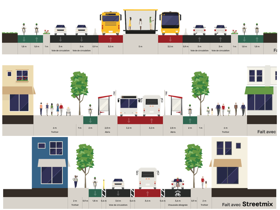
Figure 11: Adaptation of existing expressways, avenues and main roads to prioritise frequent mass transit and continuous and safe cycle paths. (Pierre Helwig with Streetmix)


Measure T5: Implementing express coaches at the departmental level

We assessed the implementation of an express coach network at the departmental level on a simple basis. The first approach considered was the possibility of relying on the department’s road network, which is the structuring road network of the territory since it irrigates all municipalities. Running an express coach on each of these roads every hour from 5 am to midnight (20 return trips per day) from Monday to Saturday, and every 2 hours on Sunday (10 return trips), would lead to a overall service of 25.1 million coach.km/year which, valued at €5 million/km, would amount to an operational cost of €126 million/year/department (T5.c).

To offer this service, the department requires a fleet of big-enough vehicles. The number of coaches needed was estimated, considering a commercial speed of 40 km/h and a reserve rate of 10%. Thus, with 208 vehicles needed, each valued at €0.25 million, the total investment would represent €52 million/department (T5.b). Consequently, rolling this out across the 100 French departments would necessitate about 20,000 vehicles, with France already having a fleet of 66,000 coaches, including 35,000 that are certified Crit'air 1 or 2 6.

To ensure a commercial speed and a high level of reliability, one possible option would be to provide reserved lanes for express coaches in all areas likely to be affected by road congestion. These reserved or dedicated lanes would be guaranteed to be financially viable, simply by choosing to reallocate existing lanes, without requiring heavy works or land acquisitions. We estimated that 10% of the departmental road network could be affected by this, which at €0.15 million/km of development would represent a total investment of €57 million/department (T5.a).


12 Helwig.png

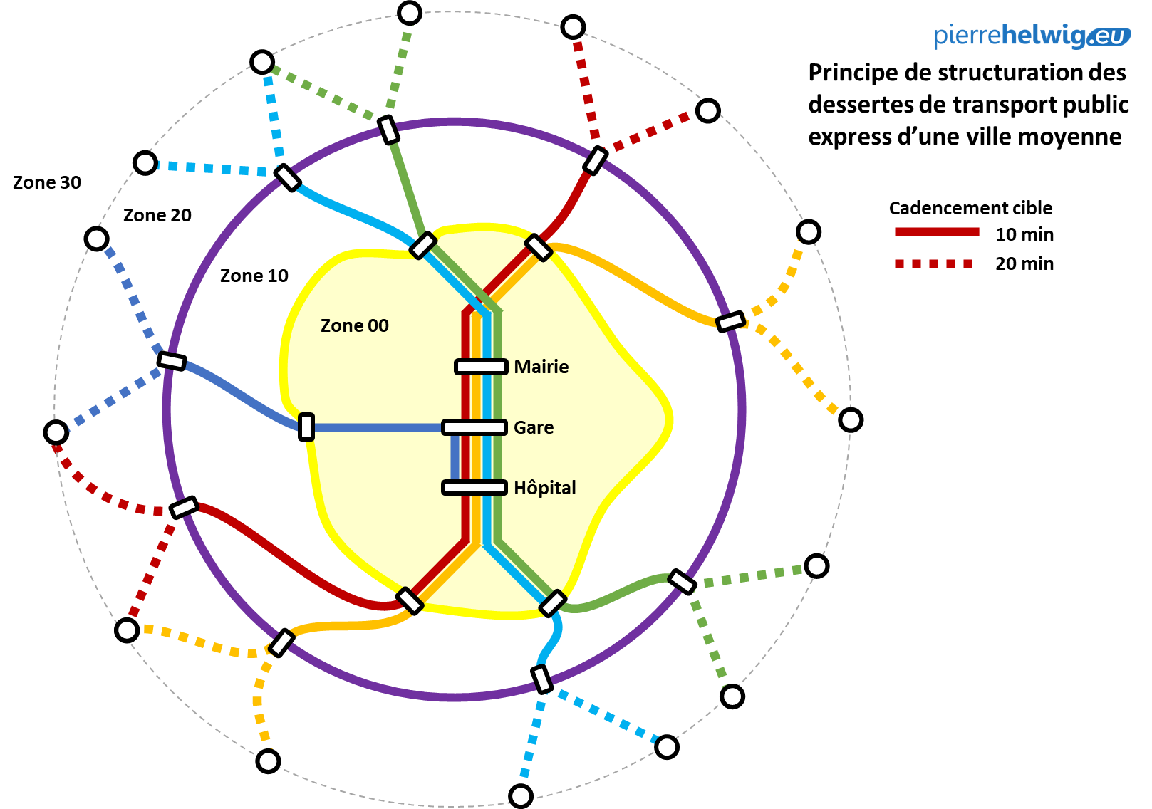
Figure 12: Example of how to structure a mass transit service for a medium-sized city: 4 or 5 radial lines with services every 10 minutes; branches serving all peripheral poles every 20 minutes; reliable schedules thanks to dedicated lanes and priority at traffic lights on shared lanes ; 2 ring road lines running every 10 minutes, one around the city centre, the other connecting the town centres of the inner suburbs, to connect the radial lines and offer efficient and reliable journey times. (Pierre Helwig)

The proposed level of service would be defined through zoning, in such a way as to make the services consistent and comprehensible on a national scale, both for residents and visitors:

  • rural areas of each department would be served every 30/60 minutes during rush hours by express lines and would thus be designated as "zone 30";
  • sectors within towns and cities would be served every 20 minutes throughout the day, and would become "zone 20";
  • denser urban areas would be served every 10 minutes, with the branches of two different lines joining together, and would be called "zone 10";
  • finally, city centres with increased frequency due to the layering of several lines would be "zero emissions" areas with limited traffic due to free public transport, and would be called "zone 00.”

13b Synthèse Technique.PNG

Figure 13: Summary of technical proposals according to geographical sectors. (Pierre Helwig)

By reallocating existing resources, we can realistically offer, throughout France, a service that is based on both

  • fast and frequent public transport (express coaches throughout, supplemented by express trams with greater capacity in the most densely populated areas)
  • a fine network of roads adapted to the practice of active mobilities.

If such a system is put in place, it will be hard to argue that managing daily mobility without a car requires lowering one’s quality of life.

The second step will therefore be to gradually encourage everyone to favour more sustainable mobility solutions to reduce the intensity of road traffic, both in volume and scope, and thus achieve a real carbon-free mobility in line with climate goals.

2/ Acting on mobility practices (economic lever): How to reduce the intensity of motorised traffic, in volume and range?

To reduce the energy intensity of all daily mobility and thus encourage everyone to transition to more sober solutions, we must not only transition to the least energy-consuming modes, but also reduce the intensity of mobility, i.e. how fast, how frequently and how far we travel.

To encourage people to switch to the least energy-intensive modes, we need to make collective modes and active modes more attractive than individual modes and motorised modes respectively, both economically and temporally. To reduce the intensity of mobility, we need to prevent new territories from being open to urbanisation and gradually relocate living spaces and activity zones to closer or more easily accessible areas via public transport, while organising the economic viability of the mobility services put in place, in particular public transport.

To do this, two economic levers must be activated.

  • The first is to bring public transport fares in line with the cost of parking for individual vehicles on roads or in car parks.
  • The second lever aims to integrate the localisation costs by adapting housing and business taxes to the urban planning costs borne by the community.

2.1 Overhauling fares for daily mobilities

Until now, each network or transport authority has implemented its own fee schedule and therefore set the fares for using its services, such as the fare for a single ticket, the fare for a pack of 10 single tickets, or the price of monthly and annual subscriptions. The rates can vary to account for the user’s household resources (social subsidies) or their individual status (student, senior citizen, large family).

However, this fare system is flawed in many ways: it is generally attractive to travel pass holders, but comparatively unattractive for occasional use, thus favouring regular users while neglecting newcomers who are then more likely to keep using their car. Also, the geographical range of travel is often unevenly reflected in the fares. Furthermore, the task of coordinating the different public transport services operating in a given territory or between several territories is too complex for public authorities and therefore it is generally left to the user to deal with multiple fare systems and sometimes totally incompatible tickets.

Implementing a new unified fare schedule on a large scale, at a regional or even national level, would be possible by adopting a universal system: a unit price would be set for 2 hours of travel within a city, considered as the base level of zoning. 24 hours of travel would cost double this rate, with decreasing rates for weekly, monthly and yearly fares. A similar rationale would give access to large territories: for example 3 zones would equate to an entire department, 3 departments to an entire region, 3 regions to the entire national territory, etc.

Parking prices are just as complex as those of public transport, although only urban centres are currently concerned. When one arrives in a city, it is impossible to know in advance which area is accessible by car and how much the parking will cost. It is often dependent on how far a space is from the city centre, but also on the day of the week and the time of day - and there is often little consistency between the rates for street parking and carparks, and between parking fines. Furthermore, the demand for parking is generally higher the closer one gets to the densest part of the urban centre, which is where, inherently, there is the least amount of public space available. Constrained public spaces require decisions on priorities and these should above all give access to active and collective mobilities, which assumes banning individual cars from the centre as much as possible.

One way forward would be to bring parking and public transport pricing in line with each other. In cities, parking should systematically be charged, while park and ride facilities should be free provided one uses public transport. In city centres, parking could be banned and public spaces largely pedestrianised, in return for free public transport services. Thus, everyone would be encouraged to park further away from the city centre and use public transport, while still keeping open the possibility of accessing dense areas for occasional use.

14b Synthèse Economique.PNG

Figure 14: Summary of economic proposals by geographical sector (Pierre Helwig)

2.2 Overhauling urban planning taxation and the location of activities

Beyond prioritising the use of the most energy-efficient mobility solutions, the challenge is also to reduce the length of distances travelled, which implies both reducing the frequency of the longest journeys and, in the longer term, bringing residential spaces closer to the destinations where people regularly want to go. However, under the current system, everything encourages peri-urbanisation and urban sprawl. Indeed, the lack of restrictions on unfettered mobility puts all territories in competition and prevents the spatial regulation of land use. However, while building on more affordable land initially seems more advantageous for some, the collective cost of periurbanisation and land take is unsustainable.

Under the current system, each municipality tries to attract more and more inhabitants, jobs and shops, with these activities generating tax revenues or even capital funds. However, implementing these new uses requires public investments such as roads, schools, networks of all kinds, which must be collectively financed. For each individual, choosing to live further away implies long daily trips – necessarily in an individual vehicle – to go shopping, to go to work, to accompany children to their various activities, all of which generates unpredictable amounts of unavoidable costs.

However, we could incentivise each actor to optimise their daily energy use by prioritising, where possible, active modes over motorised modes and public transport over individual vehicles, and to reduce the number and scope of trips. To this effect, employers could be encouraged to limit the parking spaces available for employees, encourage a stable amount of telework and support employees who wish to relocate, rather than endlessly financing their daily travel expenses. For local authorities, the effective pooling of fiscal resources at the scale of living zones should put an end to the multiplication of business areas and residential areas that are collectively unmanageable and unsustainable.

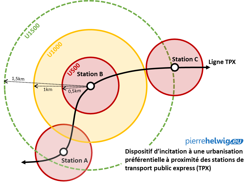
In connection with the above, it would therefore be advisable to re-examine the local taxation system in order to gradually implement taxation connected to where activities are located in the territory. This urbanisation tax would aim to encourage a gradual relocation of all activities as close as possible to mass transit stations and urban amenities, so as to promote a more contained urbanisation that naturally favours shorter trips and the mass use of active mobilities and public transport. Combined with a rapid increase in collective mobility offers and more peaceful roads, such taxation could thus compensate for the speculation on land rents that leads to the natural increase of the price of land located near centralities and attractive transport hubs, and which, step by step, leads to urban sprawl.

The urbanisation tax would even become the effective operational tool of the Territorial Cohesion Plans (known as SCoT), allowing authorities to guide the preferred location for urbanisations, encouraging all actors to relocate as close as possible to the sustainable mobility services put in place, all the while planning a progressive assessment of tax rates in order to have visibility over several years. Such a tax system would also allow us to integrate the collective costs of individual choices in order to gradually balance out the decarbonisation goals, but also to ensure that the developments are properly financed and the mobility services put in place are sustainable.

For example, three types of urban "zones" could be imagined:

  • U500 zones that correspond to a perimeter of 500 meters (i.e. 5 min walking) around a station, in which taxation would encourage a high urban density associated with the presence of shops, jobs and facilities for local life or central function.
  • U1000 zones up to 1 km as the crow flies (i.e. 5 min by bike, 15 min walking), in which taxation would encourage a lower urban density that promotes dwellings with gardens and peaceful streets offering quality living environments.
  • U1500 or U2000 zones up to 2 km as the crow flies (i.e. 10 min by bike, 30 min walking), where taxation would be low for activities requiring more space, but high for housing, jobs or businesses so as to deter the establishment of traffic-generating places far removed from the structuring transport services.

15 Helwig.png

Figure 15: Urbanisation taxation scheme according to distance to mass transit stations

In order to break out of a system that is leading us inevitably into a dead end and to overcome our collective inability to act on the immensely complex challenges we face, we must restore coherence to the rules aimed at organising a more reasonable and economical use of land both in terms of space and economic and energy costs. In order to establish such mechanisms in a coordinated and coherent manner at all scales and in the short term, we recommend reforming how public decision-making process are organised in order to integrate interdependencies.

3/ Acting on spatial planning (institutional lever): How to make mobilities and territories resilient within 10 years?

Once alternative mobility solutions to cars are implemented for all and across all territories, and economic incentives to encourage the increasing use of these alternative solutions are put in place, in order to achieve the mobility decarbonisation goals, we need new foundations for collective decision-making. This means, on the one hand, allowing planning documents to fully play their part, that is by not only incorporating global and long-term imperatives into all decisions, whether they are short-term or more local, but by leaving sufficient leeway to encourage democratic choices despite these constraints. Land planning requires decisions to be made regarding how the land is used, where infrastructures are located and how mobility solutions are used.

Therefore, accessibility goals and sobriety constraints must be integrated in advance, in the planning stage. To achieve this, we should:

  • on the one hand, coordinate planning documents to make them interdependent, which means that large-scale documents should be binding on more local documents, but conversely, the drafting of local documents should inform global planning, to ensure that bold choices are made while avoiding favouring certain territories to the detriment of others;
  • on the other hand, coordinate the financing and equalisation processes between different levels and present and future needs, so as to achieve a progressive balance between current and future expenses and revenues, which implies rethinking projects so that they are as useful and economical as possible in order to maximise their benefit and maintain a better quality of life in a world undergoing degrowth.

3.1 Coordinate decision making levels through interdependent documents

In the new architecture, each level of decision-making has its own legitimacy, and must decide on which rules are applicable to lower levels: this is called subsidiarity. The lower levels, however, must also be able to provide a counterbalance by taking part in the decisions that will be binding on them, which is enabled by a bicameral parliament. As such, a system of institutional federalism with a principle of subsidiarity and a bicameral deliberative body should allow for a constant balance between the different levels of decision-making to ensure that the best choices are made, in all circumstances.

In terms of land planning, such an institutional reorganisation would imply that all planning documents be necessarily interdependent, whether in terms of thematic area or geographical perimeter. The goal would be to achieve a gradual rebalancing of living zones to make them as self-sufficient as possible and preserve essential natural resources for long-term sustainability (e.g. a forest) while providing for short-term needs (e.g. building homes). To this end, we recommend reorganising land planning in the following way.

The Regional Land Planning Plans (SRADDET) drawn up at the regional level would determine, more broadly than today, the structure of major transport and energy infrastructures, the natural areas to be preserved, as well as the location of major regionally-managed establishments such as universities or hospitals, so that each department in the region has essential amenities accessible to the greatest number of people.

The Territorial Coherence Plan (SCoT), which would be made binding and designed at the departmental level, would aim to precisely define the constraints in terms of land use and planning that the Local Urbanism Plans (PLUi), drawn up by the municipalities, would have to respect. The SCoT would therefore strictly set the limits of the urban development, the location and typology of commercial spaces, employment areas, residential spaces, and green spaces. The SCoT would also determine the structure and service levels of mass transit as well as road typologies, including the network of pathways for active modes. Adding such coherence to the structure of travel generators and to the consistency of mobility services would be unprecedented and would finally allow us to gradually restore some balance to these two levers of regional planning.

Finally, the Local Urbanism Plans (PLUi) would only be a refined version of the SCoT, intended to fine tune the typology and physiognomy of buildings, the nature of shops, the layout of public spaces, and the preservation of historic sites.

3.2 Coordinate decision making timeframes through interdependent budgets

Today, tax revenues are mainly levied at the national level and redistributed to local authorities in the form of decentralisation grants (to finance the costs related to decentralised powers) or operating grants (to finance public services in deficit). Investments are supported through multi-year State-Region Project Contracts (Contrats de projets Etat-Région, or CPER), during calls for projects that award specific subsidies, or by cross-financing between institutional levels, often according to the emergence and commitment of projects.

Greater federalism in the power structure would allow us to better regulate the resources between different institutional levels to ensure a balance of revenue and expenditure, safeguarding the durability of decisions and the sustainability of spatial planning. To this end, by overhauling the financial flows and budgetary mechanisms between the different institutional levels, we could gradually balance the available resources and allocated expenditures and re-examine long-term investments in light of short-term operating expenses.
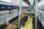
Such an idea would in fact amount to extending and generalising the mechanism of axis contracts 7 to all territories, in order to plan in a precise, sustainable and intelligible way how the land is used, how public spaces are laid out, how accessible places are by public transport and active modes, and the location of jobs, centralities, facilities and parks.

In terms of expenditure, the challenge will be to make the mass transit service more durable and reliable by defining the main lines and stops that will benefit from regular and frequent services, with longer operating hours, like the Parisian "metro" where the service runs frequently, continuously and reliably, in all circumstances, and will continue to do so tomorrow and in 50 years.

In terms of revenue, the challenge will be to set up a tax system for urbanisation for both inhabitants and companies, and that would depend on the level of service and therefore on the accessibility and attractiveness of the territory. We recommend establishing progressive zoning at 5/10/15 minutes walking distance from a frequent mass transit main line, so as to redirect urban densification projects towards areas where the public transport services will be the most efficient and economical to operate without first requiring heavy developments.

Conclusions

If we are to embark on a path that is compatible with limiting global warming to 2°C, the necessary transition should enable a fundamental change in direction. The mobility sector often appears to be one of the hardest to decarbonise, so much so that most policies - in particular the National Low-Carbon Strategy (SNBC) in France - rely on the prospect of technological improvements in terms of energy vectors (electric cars, hydrogen cars) or digital optimisation tools (Maas, automation, etc.). While this has the benefit of challenging mobility practices, it does not allow for sobriety goals to be translated into daily practices or for projects to be redirected towards more sobriety.

Yet we no longer have time to procrastinate: the solutions we need to implement are simple, economical and above all, they already exist! Rather than focusing on the search for new technologies, innovation could above all allow us to identify good practices, simplify existing systems and generalise methods to deploy solutions that are already proven to work locally to all territories and at all scales, so that we can make a shift within a few years and with limited - and inevitably diminishing - resources.

Public action at every level should be guided by an understanding of the global constraints that we all face, to share the efforts and distribute the resources evenly and democratically. Being able to decide, assess and support such a structural and complex transformation requires us to re-examine the usefulness and effectiveness of all public policies, particularly those related to the management of regional planning and mobility organisation. To leverage expertise from the field and the wealth of knowledge between territories, we must urgently adapt our decision-making methods to promote coordination, assessment and democratisation, because the consequences of our choices are more than ever collective.

Notes

1  Source: CITEPA.

2  Exact title: 'Payment intended to finance mobility services' [versement destiné au financement des services de mobilité].

3  The figures are established on the total length of departmental network of tracks, excluding the overseas departments (DOM) (1/100th of 377,890 km).

4  Key figures on transport, 2020 edition, Ministry of Ecological Transition.

5  See https://journals.openedition.org/rhcf/1326 and https://journals.openedition.org/rhcf/2028

6  Source: Ministry of Ecology / SDES-RSVERO, fleet of coaches in circulation on 1 January 2021

7  Axis contracts (contrats d’axe) aim to promote planning developments along main transport routes with increased transport services, for example through commissioning a tramway or a BRT, to ensure that significant numbers will use the service and ultimately contribute to making the investment profitable. These axis contracts, which are still rare in France, are the French version of what is known, in the English-speaking world, as Transit oriented development (ToD).

Mobility

For the Mobile Lives Forum, mobility is understood as the process of how individuals travel across distances in order to deploy through time and space the activities that make up their lifestyles. These travel practices are embedded in socio-technical systems, produced by transport and communication industries and techniques, and by normative discourses on these practices, with considerable social, environmental and spatial impacts.

En savoir plus x

Long-distance travel

Long-distance travel is variously defined, with reference to either distance, travel time, overnighting or being outside of a person’s usual environment. When defined by distance (for example, over 100km), it typically accounts for the top 1-2% of trips.

En savoir plus x

Active Mobility

Active mobility refers to all forms of travel that require human energy (i.e. non-motor) and the physical effort of the person moving. Active mobility occurs via modes themselves referred to as “active,” namely walking and cycling.

En savoir plus x

To cite this publication :

Pierre Helwig (31 January 2023), « 100 “metro” networks to serve the whole of France », Préparer la transition mobilitaire. Consulté le 03 December 2024, URL: https://forumviesmobiles.org./en/project/15536/100-metro-networks-serve-whole-france


Licence Creative Commons
Projects by Forum Vies Mobiles are licensed under a Creative Commons Attribution-NonCommercial-ShareAlike 3.0 France License.
Permissions beyond the scope of this license may be available at contact.